Our "Long Day" started at 8:30 am and ended around 8:30pm. The wander to the first cave wasn't that far and never is due to excitement. The mapping went much easier than usual since we had more people. Usually I am the scout/survey station-finder/station flagger-numberer/target holder. Finding the stations means a lot of back and forth running about since you have to think and find stations about 3 stations ahead for it to go smoothly. You have to find the direction the cave is going, make sure you have lines of sight, and make sure you place them properly at junctions to make further side-shoot or side-room surveys easier. Then you have to flag them, number them, hold the target so measurements can be taken. In water this is extremely difficult. This cave was water free and we had more help! I could find the stations while Julie flagged and numbered them and we could relay back and forth whether the line of sight would work. Very nice and much easier! Here's Julie at a nice formation at the beginning of the cave Tom has now named Cueva Rendija - peephole cave. At the end he popped up into a small passage, looked up and ended up peeping outside the cave. His fascination with this slit and the wind moving through it led to its name.
After the mapping was pretty much ending we looked into this tiny spot and it looked like it went further.
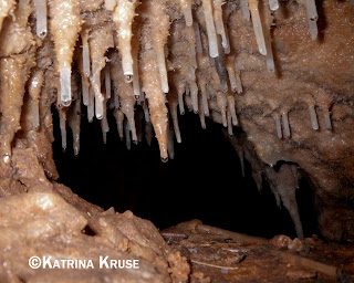
It was very decorated and none of us wanted to break things off but I figured I could take off the helmet and worm my way in without doing damage. I did have to do some bendy stuff to get in but then it opened up so I could squat, then went some more if I went on my belly, then opening etc etc. It was gorgeous!
Clearly no one had been in there - nothing was broken, there weren't muddy stalagmites, no footprints or anything on nice white deposits. There were helictites, sorbetos, cave pearls and other neat formations.
A lot of anti-gravity stuff. Julie was flexible enough to worm in so we could pseudo map it. There wasn't enough room to lift your head to use the disto or inclinometer or compass really so we used a measuring tape and top/bottom/left/right estimates. Since it was kind of tight we wouldn't be off much. It finally did end at this stalactite "jail." I could see flowing water through the bars that were a finger or two wide.
We spent a teeny bit of time admiring the formations on the way out as we carefully maneuvered our way back out to the others waiting outside. It was like a private gallery showing in there!
We exited, headed up and down to another cave, through it to another, Tom placed some equipment in a bat "hot" room and then it was out to the crazy "hand line" that I did not have the energy/strength to climb (40 feet or so of arm strength). It all went downhill from there for me. I was the weak link on this trip. I was overheated, didn't eat enough, dehydrated, tired, and I really don't know what was wrong with me. I was fine until that last cave. It was only around 4 miles total but the steep terrain made it suck. The lack of trail made it suck. The darkness and humidity made it suck. But that tiny tunnel made it worth it! Plus it got mapped so there isn't anything undone there except finding the peephole from the outside. I am NOT going on that trip!


3 comments:
Hope you're feeling better. Hydration is so important in this climate! -- Fran
Beautify pictures...but darn it just gives me chills to even think about being in a tight area like that.
Wonderful photos as usual. Like Rosa said, small spaces, no way. Glad to see it through your eyes/lens.
Wil
Post a Comment